


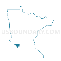
Stoneham Twp. Voting District, Chippewa County, Minnesota
About
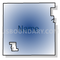
Outline

Summary
| Unique Area Identifier | 601469 |
| Name | Stoneham Twp. Voting District |
| County | Chippewa County |
| State | Minnesota |
| Area (square miles) | 34.79 |
| Land Area (square miles) | 34.75 |
| Water Area (square miles) | 0.05 |
| % of Land Area | 99.86 |
| % of Water Area | 0.14 |
| Latitude of the Internal Point | 44.92708780 |
| Longtitude of the Internal Point | -95.44750500 |
Maps


Graphs
Select a template below for downloading or customizing gragh for Stoneham Twp. Voting District, Chippewa County, Minnesota


Neighbors
Neighoring Voting District (by Name) Neighboring Voting District on the Map
- Clara City Voting District, Chippewa County, MN
- Crate Twp. Voting District, Chippewa County, MN
- Granite Falls Twp. Voting District, Chippewa County, MN
- Havelock Twp. Voting District, Chippewa County, MN
- Leenthrop Twp. Voting District, Chippewa County, MN
- Lone Tree Twp. Voting District, Chippewa County, MN
- Maynard Voting District, Chippewa County, MN
- Rheiderland Twp. Voting District, Chippewa County, MN
- Wang Twp. Voting District, Renville County, MN
Top 10 Neighboring County Subdivision (by Population) Neighboring County Subdivision on the Map
- Clara City city, Chippewa County, MN (1,360)
- Maynard city, Chippewa County, MN (366)
- Rheiderland township, Chippewa County, MN (269)
- Granite Falls township, Chippewa County, MN (253)
- Wang township, Renville County, MN (249)
- Leenthrop township, Chippewa County, MN (243)
- Stoneham township, Chippewa County, MN (241)
- Crate township, Chippewa County, MN (211)
- Lone Tree township, Chippewa County, MN (199)
- Havelock township, Chippewa County, MN (181)
Top 10 Neighboring Place (by Population) Neighboring Place on the Map
Top 10 Neighboring Unified School District (by Population) Neighboring Unified School District on the Map
Top 10 Neighboring State Legislative District Lower Chamber (by Population) Neighboring State Legislative District Lower Chamber on the Map
Top 10 Neighboring State Legislative District Upper Chamber (by Population) Neighboring State Legislative District Upper Chamber on the Map
Top 10 Neighboring 111th Congressional District (by Population) Neighboring 111th Congressional District on the Map
Top 10 Neighboring Census Tract (by Population) Neighboring Census Tract on the Map
- Census Tract 9504, Chippewa County, MN (2,239)
- Census Tract 9505, Chippewa County, MN (2,238)
- Census Tract 9503, Chippewa County, MN (2,056)
- Census Tract 7903, Renville County, MN (1,921)